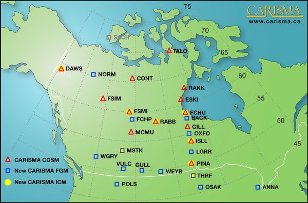
CARISMA Station Locations
The following map (click to enlarge) and table list all the sites in the CARISMA magnetometer array. The colour key indicates an original CGSM (the CANOPUS network) in red, a site that is part of the CGSM expansion in blue, and an upcoming site deployment in grey. CARISMA sites fitted with a pair of Induction Coil Magnetometers (ICMs) are shown in yellow.
The above map is also available as a PDF: CARISMA_map.pdf
| Site | Site | Geodetic | Geodetic | CGM | CGM | ||
| Code | Name | Latitude | Longitude | Latitude | Longitude | L | |
| ANNA | Ann Arbor | 42.417 | 276.098 | 52.88 | 349.51 | 2.79 | |
| BACK | Back Lake | 57.707 | 265.794 | 67.32 | 333.52 | 6.83 | |
| CONT | Contwoyto | 65.754 | 248.750 | 72.82 | 304.82 | 11.64 | |
| DAWS | Dawson City | 64.048 | 220.890 | 65.90 | 273.89 | 6.09 | |
| ESKI | Eskimo Point | 61.106 | 265.950 | 70.52 | 333.15 | 9.13 | |
| FCHP | Fort Chipewyan | 58.769 | 248.894 | 66.23 | 308.55 | 6.25 | |
| FCHU | Fort Churchill | 58.763 | 265.920 | 68.32 | 333.54 | 7.44 | |
| FSIM | Fort Simpson | 61.756 | 238.770 | 67.23 | 294.29 | 6.78 | |
| FSMI | Fort Smith | 60.017 | 248.050 | 67.28 | 306.90 | 6.81 | |
| GILL | Gillam | 56.376 | 265.360 | 66.03 | 333.05 | 6.15 | |
| GULL | Gull Lake | 50.061 | 251.739 | 58.20 | 314.92 | 3.66 | |
| ISLL | Island Lake | 53.856 | 265.340 | 63.62 | 333.36 | 5.15 | |
| LGRR | Little Grand Rapids | 52.035 | 264.537 | 61.81 | 332.38 | 4.55 | |
| MCMU | Fort McMurray | 56.657 | 248.790 | 64.17 | 309.20 | 5.35 | |
| MSTK | Ministik Lake | 53.351 | 247.026 | 60.61 | 307.99 | 4.22 | |
| NORM | Norman Wells | 65.257 | 233.311 | 69.53 | 285.74 | 8.31 | |
| OSAK | Osakis | 45.871 | 264.917 | 55.81 | 333.20 | 3.22 | |
| OXFO | Oxford House | 54.929 | 264.713 | 64.60 | 332.28 | 5.52 | |
| PINA | Pinawa | 50.199 | 263.960 | 59.98 | 331.75 | 4.06 | |
| POLS | Polson | 47.664 | 245.791 | 54.71 | 308.04 | 3.04 | |
| RABB | Rabbit Lake | 58.222 | 256.320 | 66.85 | 319.11 | 6.57 | |
| RANK | Rankin Inlet | 62.824 | 267.890 | 72.22 | 335.97 | 10.89 | |
| SACH | Sachs Harbour | 71.980 | 234.770 | 76.17 | 280.31 | N/A | |
| TALO | Taloyoak | 69.540 | 266.450 | 78.28 | 330.93 | N/A | |
| THRF | Thief River Falls | 48.027 | 263.635 | 57.82 | 331.49 | 3.58 | |
| VULC | Vulcan | 50.367 | 247.020 | 57.65 | 308.84 | 3.55 | |
| WEYB | Weyburn | 49.693 | 256.200 | 58.55 | 320.93 | 3.73 | |
| WGRY | Wells Gray | 51.883 | 239.974 | 57.75 | 299.92 | 3.57 |
*CGM coordinates for 2009 at 100 km calculated using http://nssdc.gsfc.nasa.gov/space/cgm/cgm.html


